Hurricane Dorian is weakening in strength but expanding in size, all the while still packing a “catastrophic” punch as it crawls across the northern Bahamas toward Florida.
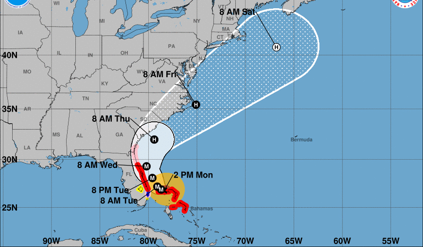
Landfall over the U.S. looks increasingly less likely, although Florida, Georgia, and the Carolinas are not out of danger yet as the timing of Dorian’s hook to the north and northwest remains key to how close its hurricane-force effects will get to the East Coast through the week.
Recommended Stories


The northern islands of the Bahamas, where there have been widespread reports of damaged roofs, overturned cars, and downed power poles, are still getting battered, even as Dorian dropped to Category 4 strength on Monday. Still a powerful “major” hurricane with 150-mph sustained maximum winds, Dorian can muster wind gusts up to 190 mph and storm surge 18 to 23 feet above normal tide levels.
“This is a life-threatening situation. Residents on Grand Bahama Island should not leave their shelter when the eye passes over, as winds will rapidly increase on the other side of the eye. Residents in the Abacos should continue to stay in their shelter until conditions subside later today,” the National Hurricane Center said in an afternoon advisory. “These hazards will continue over Grand Bahama Island during most of the day, causing extreme destruction on the island.”
Dorian is drifting a little north of due west this afternoon. As of 2 pm Hurricane Dorian was located 25 mi northeast of Freeport, Grand Bahama Island or 105 mi east of West Palm Beach FL with max sustained winds of 150 mph, a central pressure of 938 mb/27.70.” pic.twitter.com/UHnKqV4ww6
— NWS Eastern Region (@NWSEastern) September 2, 2019
Although the center of Dorian is still 100 miles east of West Palm Beach, rain bands and strong wind gusts associated with the hurricane have already reached the Florida peninsula. Much of the Florida coastline has been placed under a Hurricane Warning, and a Hurricane Watch extends from northern Florida into Georgia.
Hurricane #Dorian will parallel the Florida and Carolina coasts reaching near Cape Hatteras by Friday.
Then, Dorian should be safely east of New England as a powerful hurricane, massive in size, before it undergoes extratropical transition into Canada on Saturday. pic.twitter.com/3iwGn2QcyT
— Ryan Maue (@RyanMaue) September 2, 2019
In the coming days, a gap between high pressure systems is expected to open up, allowing Dorian to make a northerly turn. The National Hurricane Center is more certain that Dorian will not make landfall over the U.S., but will hug the coastline this week up through the mid-Atlantic as a hurricane. Still, possible landfall is not totally out of the picture, and could happen as far north as the Carolinas.
NHC Director Ken Graham said in a video update posted to Twitter that Dorian is expected to get “dangerously close” to the coast and will bring with it six to 10 inches of rain and four to seven feet of storm surge from Miami to Georgia.
.@NHC_Atlantic Director Ken Graham with the latest on #HurricaneDorian. pic.twitter.com/GvJRAgPSO9
— National Weather Service (@NWS) September 2, 2019
Right now, hurricane-force winds extend up to 45 miles from the center of the hurricane and tropical-storm-force winds extend outward up to 140 miles. That wind field is growing even as Dorian continues to diminish due to what meteorologists call an “eyewall replacement cycle” in which the inner eyewall falls apart and is replaced with a new one with a larger diameter from an outer spiral band.
The National Hurricane Center is also preaching caution in acknowledging there is still much uncertainty in the forecast. “It cannot be stressed enough that only a small deviation to the left of the NHC forecast could bring the core of the extremely dangerous hurricane onshore of the Florida east coast within the hurricane warning area,” the agency said.
Want to see more awesome imagery?
To see more photos ? and video ? from of #ReserveCitizenAirmen and Hurricane #Dorian. ✈️⛈?? Click on the link at the comment below#ReserveReady #403WG #WC130J #SuperHercules #WeatherReady #NWSNHC @weatherchannel @NOAA pic.twitter.com/A9QBibRtnB
— Hurricane Hunters (@53rdWRS) September 1, 2019
Florida, Georgia, and the Carolinas have declared states of emergency, and mandatory evacuations have been ordered in coastal areas stretching from Florida to South Carolina. President Trump approved an emergency declaration for the Sunshine State on Friday, freeing up resources and aid.
Last week Dorian became the fourth named storm and the second hurricane of the 2019 Atlantic hurricane season. It passed through the Virgin Islands and largely spared Puerto Rico, a U.S. territory that is still recovering from the devastation of the 2017 hurricane season.
The eye of #Dorian pic.twitter.com/XN29zC46IP
— Garrett Black (@GBlack22wx) September 1, 2019
Over a two-day period Dorian rapidly intensified into a powerful Category 5 hurricane with sustained 185-mph winds and has broken multiple records. It tied the record set by the Labor Day hurricane of 1935 in wind intensity when it made landfall over Bahamas on Sunday.
WATCH: “Once we come out of this with our lives, we’ll be happy.” Residents of Grand Bahama have been advised to remain in their shelters, as dangerous winds pick back up once the eye of Hurricane Dorian passes; the storm, moving west at only 1 mph, has sustained winds of 165 mph pic.twitter.com/BtqVbzlngP
— CBS Evening News (@CBSEveningNews) September 2, 2019
During an emotional press conference on Sunday, Bahamas Prime Minister Hubert Minnis said it was “probably the most sad and worst day of my life.” He added, “We’re facing a hurricane … one that we’ve never seen in the history of the Bahamas.”
Trump described Dorian on Sunday as “one of the biggest hurricanes that we’ve ever seen.”
While all eyes remain on Dorian, there is other activity in the Atlantic Ocean. The National Hurricane Center’s map of tropical activity shows at least three disturbances that could develop into tropical depressions.
NHC is monitoring 4 systems that could become tropical depressions during the next 5 days. Notably, the low in the SW Gulf of Mexico is likely to become a tropical depression as it approaches NE Mexico, and interests there should monitor the system. More: https://t.co/tW4KeFW0gB pic.twitter.com/hLDf3PWmAb
— National Hurricane Center (@NHC_Atlantic) September 2, 2019