The short plane ride from Kathmandu to Lukla, through the front range of the Himalayas, is famous not just for scenery but for thrills. The tricky part is landing, at which the pilot gets one shot: Skim over a pass, bank, and drop sharply onto a short runway sloped upward at nearly 10 degrees to bleed off speed. Taking off on the return leg is also a kick, as the plane races downhill to get airborne before the runway drops out from beneath it.
Lukla, elevation 9,400 feet, is the entry to the Everest region. Our group of 10 will spend two weeks walking from here to Everest Base Camp and back, a net ascent of 9,000 feet. A fancy GPS will eventually compute a total ascent, on the roller-coaster trails, of 25,000 feet.
Recommended Stories


Teahouses in villages along the way offer lodging and meals. Snacks, too: We’re never more than a day’s walk from Snickers, Fanta, and cans of Pringles past their sell-by dates. Rather than stay in teahouses, we camp—to keep control over our food and water and to limit exposure to other trekkers’ respiratory and gastrointestinal ailments. This costs more, since it requires a supporting entourage: two yaks, five yak/cow hybrids, two yak drivers, four porters, a kitchen staff of seven, and four Sherpa guides named Nima, Lhapka, Ngawang, and Kami.
Nima and Lhapka have each summited Mount Everest and other big peaks several times; Ngawang is a climber-in-training. Kami, the sirdar (boss), has provided logistical support to several Everest expeditions. And he knows everybody: “Kami, what’s the name of that Sherpa who climbed from Base Camp to the summit in eight-and-a-half hours? Do you know him?”
“He used to drive my yaks.”
Like most Sherpas, Kami is a Buddhist—and a devout one. On long ascents, it is a comfort to walk beside him while he quietly chants. At his request, the keeper of the Khumjung monastery opened the cabinet with their Yeti skull—the only skull I’ve ever seen with a full head of hair, which that Yeti evidently liked to part in the middle. When we reach the spectacular site of the Tengboche monastery—the high point of a ridge with a panoramic view embracing the peaks of Everest, Lhotse, Nuptse, and Ama Dablam—Kami will get us an audience with its lama.
The lama blesses each of us with a tap on the head, and a monk drapes around our necks the katas, white silk scarves, Kami has brought. We make offerings and each receive two juniper berries, a candy, and a red string. The string, to be tied around the neck, stands for the blessing’s power. It’s my one souvenir.
Our audience is a bit labored. Someone asks for advice—what could the lama offer to a Westerner about the way a Buddhist looks at the world? Kami translates the question and the lengthy reply, which is perhaps a gentle rebuke: To understand the Buddhist way takes many years of study and meditation; to such a question there can be no short answer. I try to put one in the lama’s wheelhouse: “Is it important to have a monastery in such a beautiful place?”
“Yes.” Those Buddhists get you coming and going.
In Nepali, Everest is called Sagarmatha. We had our first glimpse of it a little past the gate of Sagarmatha National Park. The summit, blasted by the jet stream, trailed its characteristic plume of blown snow. It is not a lovely mountain; its profile without the plume is unmemorable, and from tricks of perspective, other peaks often look taller. It’s simply there—a Margaret Dumont of mountains. The peak that dominates the Base Camp trek is Ama Dablam. It stands slender and alone, not jostling with bruisers along a ridge line, with a trapezoidal summit like the blade of a screwdriver.
On the flight from Philadelphia to Kathmandu, I had sat beside a climber, also named David, on his way to join an Ama Dablam expedition. Sightings of that blade raised the unsettling question of where Airplane Dave might be—and a shudder of relief at not being there, or him.
The route to Base Camp traverses steep valleys, and rivers rage along the narrow valley floors, runoff from the glaciers up ahead. They’re crossed on suspension bridges hung high in the air. After a long, wobbly stroll on one of them, solid ground seems to bounce and buck.
To acclimate, we follow (as nearly as we can) the standard rule: Sleep, at most, 1,000 feet higher each night. Being acclimated means not that your tap dancing meets the standards you’ve set at sea level but that you won’t, for example, foam at the mouth and die of pulmonary edema. On “rest” days we don’t move camp but make round-trip hikes to higher elevations. On such a hike we meet three brawny men tending a chorten, a memorial to the dead. It stands before the imposing south face of Lhotse and honors their countrymen: Poles who died attempting first ascents. One of the men speaks good English, having spent time in Lubbock, Texas. He tells stories about the dead, and then thanks us for hearing him out.
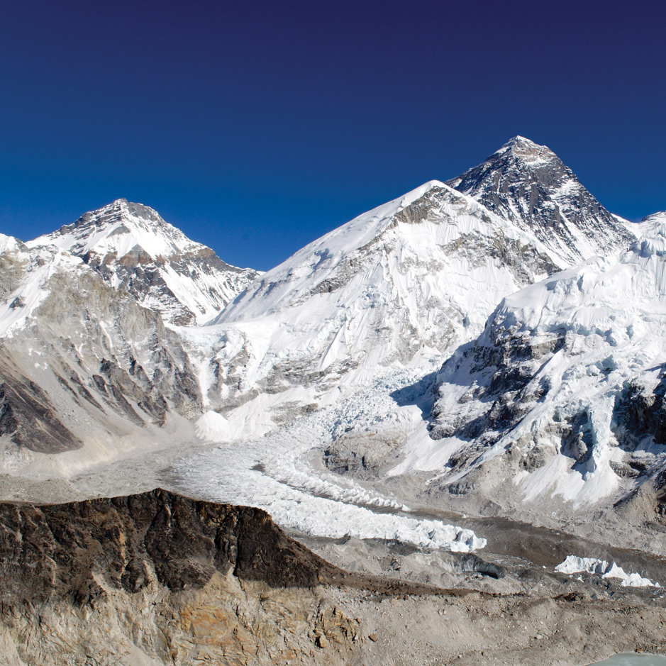
The top of Dugla Pass, through which we enter the Khumbu Valley, has chortens as far as the eye can see—including a large one for Scott Fischer, casualty of the disaster chronicled by Jon Krakauer in Into Thin Air (1997). On many others, heartbreaking epitaphs say something about who these people were: summited, died descending. Lines of small chortens remember Sherpas—many of them, if I had to guess, victims of the Khumbu Ice Fall. The Ice Fall is a steep, unstable, very dangerous part of the Khumbu Glacier that members of the support teams must repeatedly cross to ferry supplies to the higher camps.
Our most remote campsite is a yak pasture just beyond Gorak Shep. It is our highest, a little shy of 17,000 feet, and the night there is cold. The stars are fiercely bright, though large chunks of the sky are dark, blotted out by mountains.
Most of us feel the effects of altitude: headache, little appetite, no sleep. The trip from here to Base Camp is a crappy walk to a crappy (if famous) place: tediously up and down rubble and boulder fields to a bleak flat that stretches for a mile along the bottom of the glacier, empty now because the climbing season is spring, when the monsoon can push the jet stream off the summit—which, by the way, isn’t even visible from here. “Everest Base Camp” has been painted on a boulder, and (an elegant Buddhist custom) many strings of prayer flags have been unfurled. Each flag has a printed blessing and is said to give its blessing to the world when it flaps in the wind.
But nearby Kala Patthar is a joy. By local standards, it’s only a bump (18,500 feet); the massive flank of Pumori, just behind it, soars a mile higher. But it gives a spectacular view of the Everest massif. Sir Edmund Hillary’s route is evident: Go up the Ice Fall into the western cirque (mostly hidden behind the shoulder of Lhotse), gain the ridge at the South Col, hike along the ridge and over the south summit, climb the Hillary Step—and soon thereafter, as Sir Edmund is said to have remarked to his expedition mate, George Lowe, “We[’ve] knocked the bastard off.”
Boisterous groups are on top of Kala Patthar when we arrive, including some Ukrainians who proudly unfurl a Russian flag. I keep my opinion of that to myself. We’ve brought a long row of prayer flags on which we’ve added the names of friends and loved ones. Kami helps us string them up.
It will be mostly downhill from here, and rapidly so. There’s no limit to how much you can safely descend in a day—and the more you do, the better you feel. The passing of two weeks has brought a notable increase in trekker traffic, another inducement to check out mentally, to mark time until we’re home.
At Lukla, there will be beds and showers and a farewell bash with our whole crew. We offer heartfelt thanks for their hard work, high spirits, and generosity, and share plastic jugs of home brew, a kind of beer called chang, and raksi, a liquor distilled from rice. Raksi has a strong smell—a distinctive machine-shop bouquet, with notes of gasoline and WD-40—but almost no taste. The frothy chang puckers up my mouth and tongue as if I’d sucked a lemon. We all dance, most of us badly, around a yak dung stove.
Forty hours of airplanes and airports make a discontinuity so sharp it’s hard to believe I was ever on its other side. But the scene on Kala Patthar persists. One can’t always linger on a summit, but we spent a full hour. The wind was no more than brisk, the air merely cold, the sky sunny and clear. I easily shut out the presence of others: The scene, bursting with meaning, demanded all the bandwidth I could muster, and all the gratitude. Places visited again and again in imagination had become real: the Ice Fall (steeper, narrower, and scarier than I had pictured), the Yellow Band, the Hillary Step.
Around me, prayer flags snapped in the wind and spoke of loved ones. When a tear formed in the corner of my eye, I decided to blame the wind.
David Guaspari is a writer in Ithaca, N.Y. He reports that, since the April 25 Nepal earthquake, “Kami and his family are safe, though their house in the village of Khumjung has been severely damaged. There is no news as yet from Nima, Lhapka, or Ngawang. Ngawang is believed to have been guiding on a trek to Dhaulagiri, an 8,000-meter peak in the Annapurna region.”