Hurricane Dorian has proven to be a tricky storm for forecasters.
Not only is the Category 4 hurricane is moving more slowly than meteorologists first thought it would, but its expected track has also been a moving target. All the while, Dorian has rapidly strengthened over the warm waters of the Atlantic Ocean and dodged unfavorable atmospheric conditions, nearing Category 5 strength with maximum sustained wind speeds of 150 miles per hour.
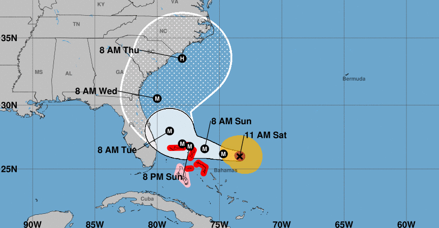
Florida may not get a direct hit as previously feared, with the forecast now showing Dorian will likely halt off its eastern coast on Tuesday before turning north and hugging the shore as it swipes Florida, Georgia, and the Carolinas. But the southeast U.S. is far from being in the clear, as the impacts from the hurricane stretch out for many miles from its center and Dorian is not expected to weaken from “major” hurricane status (Category 3 and up) until midweek.
“Looking like our great South Carolina could get hit MUCH harder than first thought. Georgia and North Carolina also. It’s moving around and very hard to predict, except that it is one of the biggest and strongest (and really wide) that we have seen in decades. Be safe!” President Trump tweeted Saturday morning.
Looking like our great South Carolina could get hit MUCH harder than first thought. Georgia and North Carolina also. It’s moving around and very hard to predict, except that it is one of the biggest and strongest (and really wide) that we have seen in decades. Be safe!
— Donald J. Trump (@realDonaldTrump) August 31, 2019
The latest update from the National Hurricane Center shows Dorian is less than 400 miles west of West Palm Beach, Florida, moving to the west at just 8 miles per hour. Between Dorian and Florida are the northwestern Bahamas, which are under hurricane warnings and face 10 to 25 inches of rain in some areas, flash floods, strong winds, storm surge, and rip currents. Tornadoes are also possible.
As the storm curls northwest, it will start to get near Florida by late Monday or early Tuesday.
Example forecast model satellite imagery of Hurricane #Dorian
Frame step is 3 hours. Watch to see the forward speed come to a halt in the Bahamas — and then head north paralleling the Florida coast.
Also, the size of the storm increases significantly on its path. pic.twitter.com/w2lY6Nme8F
— Ryan Maue (@RyanMaue) August 31, 2019
The National Hurricane Center’s forecast cone for Dorian covers a wide area that includes northeast Florida, Georgia, and the Carolinas. What this cone shows is the probable track of the center of the storm (taking into consideration a wide array of computer models) over the next few days. Therefore, landfall is possible, but with much of the cone being over the Atlantic Ocean, Dorian’s eye may also remain off the coast.
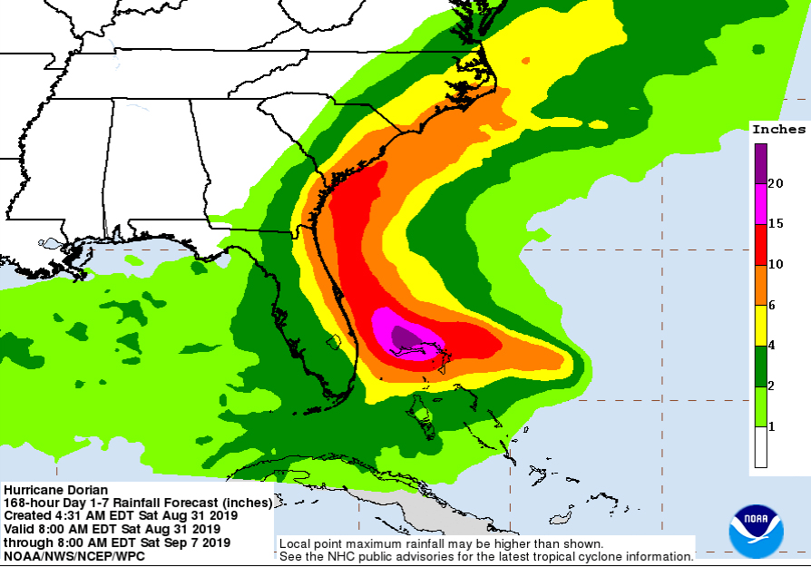
Regardless of whether it makes landfall, Dorian could bring 4 to 12 inches of rain to the southern states.
“With the change in the forecast, the risk of strong winds and life-threatening storm surge is increasing along the coasts of Georgia and South Carolina during the middle of next week,” the NHC said.
For days, Florida residents have been wiping store shelves clean and lining up for hours to get gas for their cars. After Gov. Ron DeSantis declared a state of emergency for Florida, Trump approved an emergency declaration for the Sunshine State on Friday, freeing up resources and aid. Evacuations have so far been left up to local governments.
Georgia Gov. Brian Kemp declared a state of emergency for coastal counties in his state. The governors of South Carolina and North Carolina also declared states of emergency as it became more clear that Dorian would likely make a dramatic turn north.
“Given the strength and unpredictability of the storm, we must prepare for every possible scenario,” South Carolina Gov. Henry McMaster said.
Last week, Dorian became the fourth named storm and the second hurricane of the 2019 Atlantic hurricane season. It passed through the Virgin Islands and largely spared Puerto Rico, a U.S. territory that is still recovering from the devastation of the 2017 hurricane season.