A tropical system could affect Alabama next week.
After more than a week of controversy surrounding President Trump’s warning that Hurricane Dorian could hit Alabama, forecasters are now monitoring a disturbance located east of Cuba.
Over the next few days the large area of showers and thunderstorms will head toward the Gulf of Mexico. In its 2 p.m. forecast advisory on Wednesday, the National Hurricane Center gave it a 60% chance of forming into a tropical depression in the next five days.
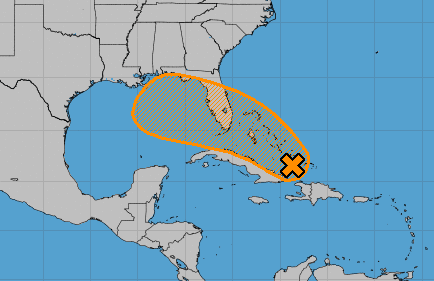
“Conditions are forecast to become more favorable for development late this week, and a tropical depression could form near the northwestern Bahamas or South Florida as early as Friday,” the agency said. “Further development is possible over the eastern Gulf of Mexico later this weekend. The disturbance will likely produce periods of locally heavy rainfall and gusty winds across the Bahamas through Friday, and across Florida during the weekend.”
A tropical depression forms “when a low pressure area is accompanied by thunderstorms that produce a circular wind flow with maximum sustained winds below 39 mph,” according to NASA. If it continues to strengthen, such a system can be upgraded to a tropical storm and later a hurricane.
The National Hurricane Center does not mention Alabama in particular, but local forecasters are already warning residents to stay vigilant. “We’re keeping an eye on the tropics as several waves have potential of developing into tropical systems.Disturbance 1 may bring rain & breezy conditions to central AL beginning this weekend, though significant strengthening is not anticipated at this time. Stay tuned for updates!” the National Weather Service office in Birmingham tweeted Wednesday afternoon.
We’re keeping an eye on the tropics as several waves have potential of developing into tropical systems.Disturbance 1 may bring rain & breezy conditions to central AL beginning this weekend, though significant strengthening is not anticipated at this time. Stay tuned for updates! pic.twitter.com/FLskquTSiJ
— NWS Birmingham (@NWSBirmingham) September 11, 2019
It is the middle of hurricane season, and tropical cyclones rolling through the Gulf of Mexico are not uncommon.
But earlier this month controversy began when Trump tweeted that Alabama and other southeastern states “will most likely be hit (much) harder than anticipated.” Twenty minutes later, the National Weather Service station in Birmingham appeared to issue a corrective tweet that said “Alabama will NOT see any impacts” from Dorian because it was projected by that time to remain too far east.
Negative press prompted Trump to lash out at the media, but backlash grew with his presentation in the Oval Office of a National Hurricane Center map of Dorian’s projected path apparently doctored with a marker to show an extension of the forecast cone reaching over the Florida panhandle and over a part of Alabama.
In fact, Dorian swung up the East Coast, making landfall over North Carolina, before speeding off to eastern Canada as a hurricane-force post-tropical cyclone. Earlier forecasts considered Alabama to be in its projected path, but a National Hurricane Center graphic shows the odds of low-end tropical storm-force winds associated with Dorian striking Alabama dropping significantly by Sept. 1, the day Trump tweeted, to roughly 5%.