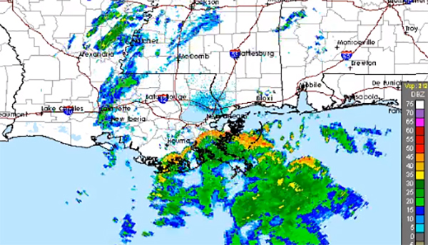
The outer rain bands of Hurricane Nate reached the southeast coast of Louisiana early Saturday afternoon as the storm continues to strengthen over the warm waters of the Gulf of Mexico.
With hours to go before the hurricane makes landfall somewhere between Louisiana and the Florida panhandle, radar imagery showed precipitation in the vicinity of New Orleans. The eye of the hurricane was also visible on local radar.
Recommended Stories


The eye of #Nate is becoming visible on New Orleans/Slidell radar. Catch the latest advisory at https://t.co/tW4KeGdBFb pic.twitter.com/jG9VhadRIX
— NHC Atlantic Ops (@NHC_Atlantic) October 7, 2017
The National Hurricane Center announced in the afternoon that Hurricane Nate is “expected” to be a Category 2 storm when it makes landfall over the U.S. Gulf Coast in the late evening Saturday – an escalation from prior forecasts.
Though not yet a “major” hurricane according to the standards set by the Saffir-Simpson Hurricane Wind Scale, a Category 2 storm is capable “extremely dangerous winds” at 96 to 110 mph that “will cause extensive damage.”
The storm was still a Category 1 hurricane with 90 mph winds, located about 100 miles south of the Mississippi River and moving at 25 mph north-north west.
The Twitter account for the National Weather Service office for New Orleans/Baton Rouge retweeted photos and video showing the first storm clouds rolling in.
Timelapse of that first squall from Hurricane #Nate. Violet, Louisiana. #LAwx @WWLTV pic.twitter.com/AgGaYJ6hmY
— Cory Reppenhagen (@CReppWx) October 7, 2017
First band of #Nate pic.twitter.com/um2R6A9jny
— Hank Allen (@HankAllenWX) October 7, 2017
“Conditions are quickly deteriorating as outer bands of Hurricane #Nate arrive. Be safe, all! We’re with you through the storm,” NWS New Orleans tweeted.
Conditions are quickly deteriorating as outer bands of Hurricane #Nate arrive. Be safe, all! We’re with you through the storm. #LAwx #MSwx https://t.co/wxV7f9qlLE
— NWS New Orleans (@NWSNewOrleans) October 7, 2017
States of emergency have been declared in Florida, Louisiana, Mississippi, and Alabama.
President Trump has approved an emergency declaration for Louisiana, unlocking federal resources. Brock Long, the administrator of the Federal Emergency Management Agency has named William Doran III as the federal coordinating officer for federal recovery operations in the affected areas, the White House said in a statement Saturday morning.
Nasty outer band of #Nate moving thru the New Orleans area- eye not very clear (yet?) #lawx pic.twitter.com/XI7vWGHToP
— Eric Blake ? (@EricBlake12) October 7, 2017
Trump tweeted that the “great team” at FEMA is “prepared” for the storm.
The Pentagon announced that two ships, the USS Iwo Jima and the USS New York, are being deployed from Mayport, Fla., with embarked elements of the 26th Marine Expeditionary Unit to the Gulf of Mexico behind the hurricane to support FEMA where needed.
Hurricane Nate brings the threat of heavy rainfall, flash flooding, “life-threatening” storm surge, surf and rip current conditions, strong gusts of wind, and even isolated tornadoes. Up to seven to 11 feet of storm surge could happen between the mouth of the Mississippi River and the Alabama-Mississippi border coasts, according to the NHC.
#ICYMI Our 6’6″ MIC w/ 11ft pole. THAT’S how high water could get along coast MS River to MS/AL line. If under evac order LEAVE NOW! #Nate pic.twitter.com/D2ebEd4gqX
— NWS New Orleans (@NWSNewOrleans) October 7, 2017
New Orleans Mayor Mitch Landrieu, whose city was devastated by Hurricane Katrina in 2005, declared a state of emergency on Thursday and some evacuations followed on Friday. The city is bracing for possible flooding as parts of the city’s drainage system are not in full working order.
“We are in a stronger place w/ power and pumps. But, if #Nate produces large amount of rainfall, we could see some localized flooding,” Landrieu tweeted Friday.
He shared pictures of himself Saturday afternoon posing with people working to fix or operate the city’s drain pumps.
I’m making rounds to check on operations at our pump stations ahead of #HurricaneNate. The team at DPS 3 is ready to go. #NolaReady pic.twitter.com/MldUmrLvgT
— Mitch Landrieu (@MayorLandrieu) October 7, 2017
The storm has been tied to at least 25 deaths in Central America so far.