Hurricane Dorian will move “dangerously close” to the Florida east coast late Monday into Tuesday, according to the National Hurricane Center.
The massive storm has battered the northern Bahamas for several hours, leaving widespread devastation in its wake, and is crawling at just 5 miles per hour. That could be bad news for the Bahamas as Dorian’s “catastrophic” effects may linger in the area for days.
Only now is Dorian starting to show signs of leveling off, but the hurricane remains an upper-level Category 5 hurricane with 185 miles per hours maximum sustained winds. Hazards facing the Bahamian islands for most of Sunday included wind gusts up to 220 mph and storm surge 18 to 23 feet above normal tide levels.
In an emotional press conference, Bahamas Prime Minister Hubert Minnis said it was “probably the most sad and worst day of my life.” He added, “We’re facing a hurricane … one that we’ve never seen in the history of the Bahamas.”
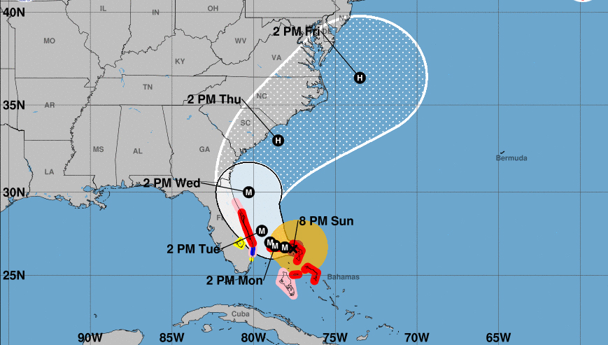
The eye of the hurricane was roughly 155 miles west of West Palm Beach as the the NHC’s 8 p.m. advisory, but Hurricane and Tropical Storm Warnings and Watches are already in effect for a long strip of the eastern Florida coast.
Florida Gov. Ron DeSantis suspended tolls on state highways on Sunday and urged residents to take evacuation orders seriously. “Hurricane #Dorian is one of the strongest storms that’s ever threatened Florida. If you live in a county with evacuation orders, please heed the call,” he said in a tweet.
Hurricane #Dorian is one of the strongest storms that’s ever threatened Florida. If you live in a county with evacuation orders, please heed the call.
I have also ordered @MyFDOT to suspend tolls on Florida’s Turnpike Mainline and selected toll roads across the state. pic.twitter.com/Aiz7bhAHUh
— Ron DeSantis (@GovRonDeSantis) September 1, 2019
President Trump approved an emergency declaration for the Sunshine State on Friday, freeing up resources and aid.
The National Hurricane Center’s forecast cone for Dorian, which has shifted back towards the west over the course of the day, covers a wide area that includes Florida, Georgia, and the Carolinas. All of these states have declared states of emergency and mandatory evacuations have been ordered from Florida to South Carolina.
? JUST IN: the new ECMWF ensemble yet again threads the needle with #Dorian, showing the storm carving a path just ~50 miles offshore from Florida to the Carolinas.
This model has generally been the most accurate in forecasting #HurricaneDorian‘s position. https://t.co/t64q8xeP95 pic.twitter.com/Y8q1HHa1s8
— Ben Noll (@BenNollWeather) September 1, 2019
What this cone shows is the probable track of the center of the storm (taking into consideration an array of computer models) over the next few days. Therefore, landfall is possible, but with much of the cone being over the Atlantic Ocean, Dorian’s eye may also remain off the coast.
Some models have shown landfall near Kennedy Space Center east of Orlando.
#HWRF model refuses to follow the model herd with offshore solution and once again has landfall in #Florida near Kennedy Space Center late Tuesday. #Dorian pic.twitter.com/xxceWECZc7
— Bill Karins (@BillKarins) September 1, 2019
Other models predict the storm will stay offshore as it hooks north, scraping the coasts of Florida, Georgia, and the Carolinas. Storm surge, strong winds, flash flooding, and heavy rain all remain possible for these areas. By the end of the week Dorian could still be a hurricane in the vicinity of Virginia and Maryland.
The National Hurricane Center said along the Atlantic Coast from the Florida peninsula through Georgia up to 9 inches of rain is possible, up to 15 inches in the Coastal Carolinas, and up to 6 inches in Southeastern Virginia.
Last week, Dorian became the fourth named storm and the second hurricane of the 2019 Atlantic hurricane season. It passed through the Virgin Islands and largely spared Puerto Rico, a U.S. territory that is still recovering from the devastation of the 2017 hurricane season.
WATCH: Hurricane Dorian makes landfall in Bahamas with sustained winds of 185 mph: https://t.co/awBoyZbH4y pic.twitter.com/E96pQ4v6Kf
— WSB-TV (@wsbtv) September 2, 2019
Dorian has already broken multiple records after it rapidly intensified over the course of two days. It tied the record set by the Labor Day hurricane of 1935 in wind intensity when it made landfall over Bahamas on Sunday.
Trump described Dorian on Sunday as “one of the biggest hurricanes that we’ve ever seen.”