Hurricane Dorian strengthened back up to Category 3 status late Wednesday just 105 miles south of Charleston, South Carolina.
The storm began to re-intensify on Wednesday after diminishing to a Category 2 thanks to an “environment of light to moderate vertical wind shear and warm sea surface temperatures,” the National Hurricane Center said.
In its 11 p.m. update, the agency said the storm succeeded in reentering “major” hurricane territory with lower barometric pressure detected by an Air Force “Hurricane Hunter” plane and maximum sustained wind speed jumping to 115 mph.
Those winds are capable of “devastating damage” in which “[w]ell-built framed homes may incur major damage or removal of roof decking and gable ends. Many trees will be snapped or uprooted, blocking numerous roads. Electricity and water will be unavailable for several days to weeks after the storm passes,” according to the Saffir-Simpson Hurricane Wind Scale.
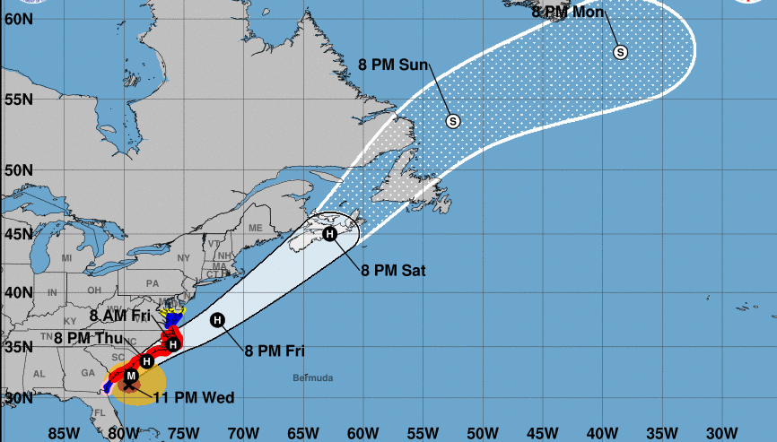
Forecasters are now closely watching how quickly the storm will again weaken and how close its core will get to the coast. Hurricane-force winds are extending outward up to 60 miles from the center of Dorian and tropical-storm-force winds extend as far as 195 miles.
#Dorian back up to Cat 3 strength
115 mph wind
moving North at 7mph
Still expected to hug the Carolina Coast over the next 24-36 hours
It’ll FINALLY pull away from the Coast an head out to sea this weekend.
@[1 – NC5_LelanStatom] has the latest tomorrow morning on @Nc5 pic.twitter.com/tT0YFRXNzx— Bree Smith (@NC5_BreeSmith) September 5, 2019
“The forecast motion should bring the core of Dorian near the coast of South Carolina during the next 6 to 12 hours and over the Outer Banks of North Carolina between 24 and 36 hours,” the NHC’s late Wednesday discussion post said. “Since the NHC track prediction continues to take Dorian dangerously close to the southeast U.S. coast, all interests from Georgia to the Carolinas should remain vigilant to the possibility of experiencing destructive winds, flooding rains, and life- threatening storm surges from this hurricane.”
The latest update from NHC shared two “key messages”:
“1. Life-threatening storm surge and dangerous winds are expected along portions the coasts of Georgia, South Carolina, and North Carolina, and portions of southeast Virginia and the southern Chesapeake Bay, regardless of the exact track of Dorian’s center. Water levels could rise well in advance of the arrival of strong winds. Residents in these areas should follow advice given by local emergency officials.
“2. Flash flooding will become increasingly likely across coastal Georgia into the eastern Carolinas overnight. On Thursday, there is a high risk of flash flooding over coastal sections of the Carolinas, where significant, life-threatening, flash flooding is expected.”
Our Airmen dedicate themselves to providing the @NWSNHC with operational data that helps increase accuracy of the forecast model. Their job may be dangerous, but is nessissary for the safety of others. ✈️⛈??#ReserveReady #403WG #WC130J #SuperHercules #WeatherReady #NWSNHC pic.twitter.com/dR5FqX5XnW
— Hurricane Hunters (@53rdWRS) September 4, 2019
Gradual weakening is projected to begin in the next 12 hours, but at the same time Dorian’s wind field is poised to expand, which could be trouble for residents along the coast even if Dorian does not make landfall. The storm, which is now moving at 7 mph, will hug the coast until Friday.
Heavy rain, strong winds, dangerous storm surge, and even tornadoes remain possibilities in the forecast not just on the coast from Florida to southern Virginia, where states of emergency have been declared and mandatory evacuations have been issued, but also in some areas farther inland.
Going to be a rough early morning for our friends in Charleston, SC with what should be the 3rd highest tide on record. Many streets will be deeply underwater and impassable. You can see the tide on its way up now. #Dorian pic.twitter.com/dGzBTH352V
— Jim Cantore (@JimCantore) September 5, 2019
“Our message today is, if you are still in an evacuation zone, you still have time to get out. But time is running out,” South Carolina Gov. Henry McMaster said Wednesday to people in evacuations zones.
By the weekend, Dorian should divert from the coast and out to sea.
This aerial footage of the Bahamas shows the destruction from Hurricane Dorian on Great Abaco Island https://t.co/3TuV2PdLdV pic.twitter.com/LXL2yc36Zb
— CNN (@CNN) September 3, 2019
The hurricane’s outer bands have already been lashing out at Florida for more than a day and before that it wreaked havoc over the northern Bahamas.
Dorian peaked as a high-end Category 5 hurricane over Labor Day weekend when it made landfall over the Bahamas. Entire neighborhoods are said to have been wiped out or under water, with as many as 13,000 homes having been damaged or destroyed in the Bahamas. At least 20 people have been reported killed by Dorian, but that figure is expected to rise as rescue crews get a better idea of the scope of the damage.
“We are in the midst of one of the greatest national crises in our country’s history,” Prime Minister Hubert Minnis said during a news conference Tuesday night.
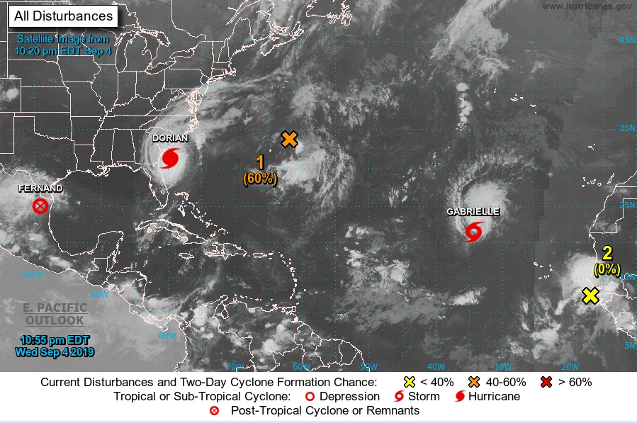
The 2019 Atlantic hurricane season, which ends on Nov. 30, has quickly become very active with the National Hurricane Center monitoring at least five tropical disturbances, including the remnants of Tropical Storm Ferdinand over Mexico and three other systems far out in the middle of the Atlantic Ocean.