Packing deadly sustained winds of 160 mph, Hurricane Dorian has been upgraded to a Category 5 storm as it begins to pummel the Bahamas and begin its slow track toward the eastern seaboard.
During its 8 a.m. update, the National Hurricane Center upgraded the storm from an already powerful Category 4 to the NHC’s highest storm-strength designation.
“#Dorian is now a category 5 #hurricane with 160 mph sustained winds. The eyewall of this catastrophic hurricane is about to hit the Abaco Islands with devastating winds,” the NHC said in a Sunday morning tweet.
NEW: #Dorian is now a category 5 #hurricane with 160 mph sustained winds. The eyewall of this catastrophic hurricane is about to hit the Abaco Islands with devastating winds. Next advisory: https://t.co/tW4KeFW0gB pic.twitter.com/oFspgN0XbT
— National Hurricane Center (@NHC_Atlantic) September 1, 2019
Dorian has been strengthening rapidly in the past few days as it continues its jaunt westward, with the NHC adding a tropical storm warning for a portion of Florida’s coast and causing the South Carolina to issue a state of emergency.
Initial mapping of the massive hurricane had it barreling across Florida and caused long lines at gas stations and water to be sold out at some stores from Miami to Naples, with some still on alert after Hurricane Irma ravished parts of the sunshine state in 2017.
Current modeling has the storm stalling out over the Bahamas, with its devastating eyewall hitting inundating the northern Bahamas with fierce winds, torrential rain, and storm surge from 10 to 15 feet above normal levels.
The Bahamian government initiated targeted evacuations of the areas that are expected to be hit the hardest, namely Abaco Island and Grand Bahama Island. There are nine hurricane shelters on Grand Bahama and 15 on Abaco. It is predicted that 73,000 residents and 23,000 homes could be affected by the storm.
Beginning to experience tropical storm force winds on Abaco Island. TS Force winds stretch more than 100 miles from the center of #hurricanedorian pic.twitter.com/5hWKzQL1hZ
— Marcus Moore (@marcusmoore) September 1, 2019
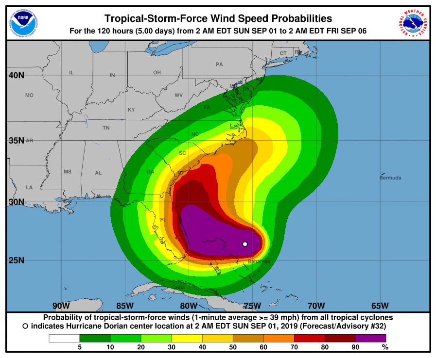
The most recent forecast cone for tropical storm force winds shows a large swath of states, including Florida, Georgia, South Carolina, and North Carolina, might suffer some of Dorian’s wrath.
The short term forecast for Hurricane #Dorian is definitely concerning.
The center will likely remain offshore but the margin for error is only 10s of miles between major hurricane conditions vs. not.
(ECMWF 06z model — @weathermodels_ ) pic.twitter.com/3Hu3mzhA0O
— Ryan Maue (@RyanMaue) September 1, 2019