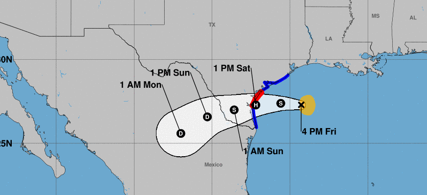
Tropical Storm Hanna is expected to make landfall as a hurricane in Texas on Saturday, according to the National Hurricane Center.
A hurricane warning has been issued from Baffin Bay up to Mesquite Bay, Texas. A storm surge warning has been issued from Baffin Bay to Sargent, Texas, including Corpus Christi Bay, Copano Bay, Aransas Bay, San Antonio Bay, and Matagorda Bay.
A hurricane warning means sustained winds are expected to reach at least 74 mph, while a storm surge warning means winds are expected to reach at least 40 mph.
The primary threat expected from the storm is severe flooding. Heavy rains are being forecast across the Texas coast and well inland, even into northeast Mexico.
Forecasters say rainfall of up to 5 inches is possible for many areas. A few communities could receive as many as 15 inches. This much rainfall could lead to some dangerous flash flooding as well as river flooding in certain locales.
Persistent winds could also create high surf, rip currents, and some possible coastal flooding at high tide.
Tropical-storm-force winds could develop as soon as Friday evening or Saturday morning. There may be some tree damage caused by the winds. Residents are being asked to fill up their gas tanks and make sure they have some cash on hand in case of a power outage.
“As Tropical Storm Hanna approaches, Texans along the coast are advised to take precautionary measures to protect life and property,” Texas Gov. Greg Abbott said on Friday. “I urge all those who are in the path of this storm to heed the warnings and guidance from local officials before the storm makes landfall. The State of Texas will coordinate with local officials to provide assistance and resources to communities in the area.”
Meanwhile, another tropical storm is heading toward Hawaii. Tropical Storm Douglas is expected to weaken but will likely hit the state on Sunday. It could be either a tropical storm or a low-end hurricane. Heavy rain, strong winds, coastal flooding, and high surf have been forecast.