Hurricane Maria made landfall Monday evening as an “extremely dangerous” Category 5 storm on the island of Dominica and is expected wreak devastation across the Caribbean over the next couple of days before making a turn north when it could dance around a meandering Hurricane Jose and send that storm flying toward the East Coast.
Only two weeks ago the Caribbean braced for Irma, a record-breaking Category 5 hurricane which wracked many of the same islands in Maria’s path.
The 11 p.m. Eastern time update from the National Hurricane Center said that Maria was directly over Dominica, a former British colony with about 72,000 residents, bringing with it 160 miles-per-hour sustained maximum winds, storm surge, and heavy rainfall. The storm is moving at about 9 mph west northwest, and several islands, including Guadelupe, St. Kitts, the Virgin Islands and Puerto Rico, are all in Maria’s direct path and have Hurricane Warnings in effect.
The storm strengthened rapidly, jumping from a Category 1 storm to a 5 within a day. A Category 5 storm is capable of “catastrophic damage,” according to the Saffir-Simpson Hurricane Wind Scale. “A high percentage of framed homes will be destroyed, with total roof failure and wall collapse. Fallen trees and power poles will isolate residential areas. Power outages will last for weeks to possibly months. Most of the area will be uninhabitable for weeks or months,” the NHC says of a Category 5 hurricane.
Winds associated with Maria “are merciless!”, said Dominca Prime Minister Roosevelt Skerrit, who on Facebook revealed he was rescued after there was flooding in his house and the roof blew off. Similar reports of damage are being made across the island. “We shall survive by the grace of God!”, the prime minister added.
#Maria made landfall on Dominica at 915 pm AST as a category 5 #hurricane with 160 mph (260 km/h) winds https://t.co/QSxq7VPr15? pic.twitter.com/3Z1Q95WYlM
— NHC Atlantic Ops (@NHC_Atlantic) September 19, 2017
President Trump approved emergency declarations Monday for both the Virgin Islands and Puerto Rico, where Maria is expected to reach by Wednesday, bringing with it rainfall totals in double-digit inches and a “dangerous” combination of storm surge and tide that could reach between 6 and 9 feet.
“Officials urge all those in homes damaged by Hurricane Irma or otherwise unsafe in a storm to seek a safe place to ride out what is likely to be Hurricane Maria,” the government of the Virgin Islands said in a Facebook post on Sunday. Puerto Rico announced on Saturday that 450 shelter across the state have been set up across the territory that can fit up to 67,714 people and that the government is “constant communication” with the White House and federal agencies. Puerto Rico officials announced on Monday that basic supplies like water and food would be rationed.
Tropical-storm-force winds could start as early as Tues night in Puerto Rico but are most likely to begin early Wed https://t.co/tW4KeGdBFb pic.twitter.com/T10NfekaEy
— NHC Atlantic Ops (@NHC_Atlantic) September 19, 2017
Maria is not expected to weaken much over the next couple days, as the NHC notes warm waters and low wind shear make favorable atmospheric and oceanic conditions for the hurricane. “Maria is expected to remain a Category 4 or 5 hurricane when it approaches the Virgin Islands and Puerto Rico, however some fluctuations in intensity are possible due during the next 24 to 36 [hours] due to eyewall cycles,” said the NHC advisory.
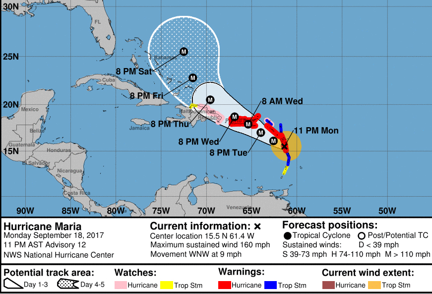
Hurricane Maria’s forecast cone. (Courtesy of the National Hurricane Center)
Some more significant weakening is expected after that as the storm is projected to turn north. However, that is when the still-present Hurricane Jose becomes a factor off the U.S. East Coast.
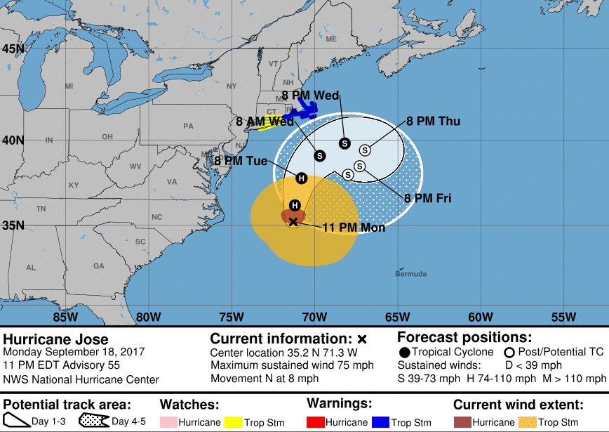
Hurricane Jose’s forecast cone. (Courtesy of the National Hurricane Center)
The long-term forecast for both storms is far from conclusive, but a couple possibilities have been discussed by forecasters.
Most models do not show Maria taking a similar post-Caribbean track as Irma did, in which it struck the the Florida Keys from the south, though the east Florida coastline will still likely see rough surf. However, it is too early to discount a sudden turn towards the Sunshine State. Most forecasters predict that Maria will steer away from the Gulf of Mexico and head into the Atlantic Ocean where it could interact with Jose, which is curling clockwise out into the Atlantic over the course of the week, weakening into a tropical storm.
According to Weather.com, if Jose were to stall, that would keep an area of high pressure over the East Coast and help send Maria out farther into the Atlantic Ocean to the north northeast, though rough surf would still be an issue for the coastline through the end of September.
Also a possibility is what meteorologists call the “Fujiwara Effect,” in which Maria and Jose could perform a sort-of dance around each other, resulting in a diminished Jose getting slung westward toward the East Coast while Maria heads north out into the Atlantic Ocean.
The U.S. has already been hit by two “major” hurricanes in recent weeks — Hurricanes Harvey and Irma, which by one estimate caused a combined $290 billion in damage. At least 82 people died in Texas in connection to Harvey, which slammed the state and its neighbors last month. Meanwhile, the death toll associated with Irma in the Caribbean and the Caribbean was as high as 69 deaths.
In Florida, where Irma made landfall last weekend, millions of people lost power, and thousands of customers are still without lights and air conditioning. Trump traveled to the state to meet with local and federal officials and people impacted by the storm as he also did in Texas and Louisiana after Harvey hit.
Hurricane season still has a way to go yet. It began on June 1 and won’t end until Nov. 30.