The killer drought that has been plaguing the West has exploded into the Northeast and Southwest in just the last five months, nearly doubling its size to cover over 21 percent of the country, National Drought Mitigation Center.
“Drought coverage has nearly doubled since reaching a 5½-year minimum of 12.41 percent on March 15, 2016. During the summer of 2016, drought coverage and intensity has increased in several areas across the Plains, South, and Northeast, but has mostly shrunk in the Midwest—except in the lower Great Lakes region,” according to Brad Rippey, USDA meteorologist.
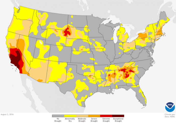
The drought is considered “extreme” in the High Plains and the Southeast and “severe” across western New York, almost all of Massachusetts, and parts of Long Island, New Hampshire, and southern Maine.
NOAA’s Climate.gov website has posted an animated map that shows how the drought has spread east.
Since it is hitting during the growing season, the drought is having a big impact. From the NOAA site, tipped to us by Bee Culture Magazine:
According to the Drought Impacts Reporter, agricultural impacts are piling up. Pastures have deteriorated, hay production has fallen, and stock ponds and creeks have dried up in the High Plains, and fire danger is high.
In Massachusetts and other parts of the Northeast, farmers are struggling to irrigate lettuce, corn and other crops that are normally sustained by rainfall, with many growers suffering significant losses. Meanwhile, many towns and cities across the region are under voluntary or mandatory water restrictions.
Paul Bedard, the Washington Examiner’s “Washington Secrets” columnist, can be contacted at [email protected]