So far so good for Mexico, a country that just 24 hours ago was bracing for the arrival of one of the strongest hurricanes ever recorded.
Hurricane Patricia, at its peak, reached sustained winds of over 200 miles per hour as it careened northeast towards Mexico’s southwest coast. Mexican authorities declared a state of emergency in the affected areas.
Recommended Stories


The National Hurricane Center, a division of the U.S. National Weather Service, warned that a “potentially catastrophic landfall” was possible and recommended that Mexican residents in low-lying areas near the coast evacuate immediately.
To compare, Hurricane Katrina, which devastated New Orleans in 2005, only reached 175 mph sustained winds at its peak.
Related Story: http://www.washingtonexaminer.com/article/2574118/
President Obama’s official Twitter account said Mexico’s neighbor to the north was ready to help.
“Our thoughts are with the Mexican people as they brace for Hurricane Patricia. [U.S. Agency for International Development] disaster experts are on the ground and ready to help,” the tweet read.
By the time the eye of the storm hit land Friday evening at 6:15 p.m. local time near Cuixmala, which is 55 miles northwest of the port city of Manzanillo, Patricia had weakened. While still a Category 5 hurricane, its sustained wind speed had dropped to 165 mph. Category 5 is the highest level in the Saffir-Simpson Hurricane Wind Scale, a ratings scale based on a hurricane’s sustained wind speed. Anything above a Category 2 hurricane is considered a “major hurricane” due to potential for loss of life and damage.
As of Saturday morning the National Hurricane Center demoted Patricia to a tropical depression (with 35 mph sustained winds) as it traveled through the interior of Mexico towards Texas. No major damage or fatalities have been reported.
Though the storm is “rapidly weakening,” the National Hurricane Center warns that heavy rainfall, flash floods and mudslides are still possible.
“So far, there are no reports of major damage from #Patricia. Our gratitude to all for your thoughts, prayers and actions #PrayForMexico,” tweeted Mexican President Enrique Pena Nieto Saturday afternoon.
The National Hurricane Center said that with sustained winds that reached up to 200 mph, Patricia was the strongest ever reached over eastern Northern Pacific. It was not, however, the strongest hurricane to make landfall. That distinction rests with Typhoon Haiyan, which clocked in at about 195 mph when it hit the Philippines in November of 2013, leaving over 6,300 dead in its wake. A typhoon is another name for a hurricane that is located in the South Pacific and Indian Ocean.
As the storm continues to weaken and make its way to Texas as the weekend progresses, severe weather in the state is still possible. Gov. Greg Abbott activated a Texas State Operations Center and freed up state resources to assist local authorities handle with any emergencies.
If nothing else, the storm did make for some dynamic pictures.
The National Oceanic and Atmospheric Administration satellites Twitter account sent out this infrared satellite image of Patricia as it reached its 200 mph peak:
#Patricia the strongest eastern north Pacific hurricane on record and heading for landfall https://t.co/xlqVx4rFwX pic.twitter.com/h7aMscWXdU
— NOAA Satellites (@NOAASatellites) October 23, 2015
A picture on the Facebook page of the NOAA Hurricane Hunters provided a glimpse of the eye of the hurricane:

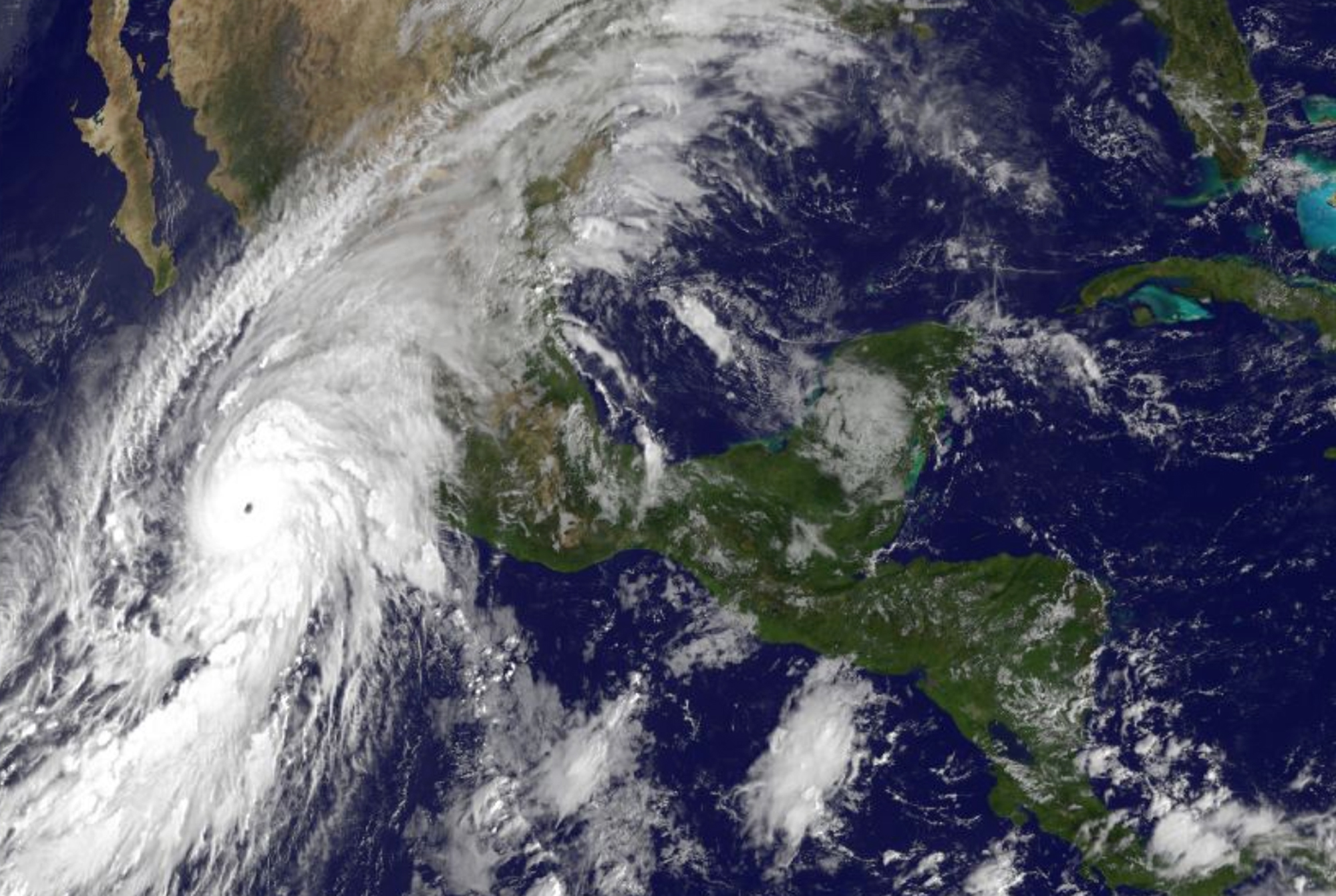
Finally, at perhaps a safer vantage point, NASA astronaut Scott Kelly tweeted this birds-eye view of Patricia from space in the International Space Station:
Hurricane #Patricia looks menacing from @space_station. Stay safe below, #Mexico. #YearInSpace pic.twitter.com/6LP2xCYcGD
— Scott Kelly (@StationCDRKelly) October 23, 2015