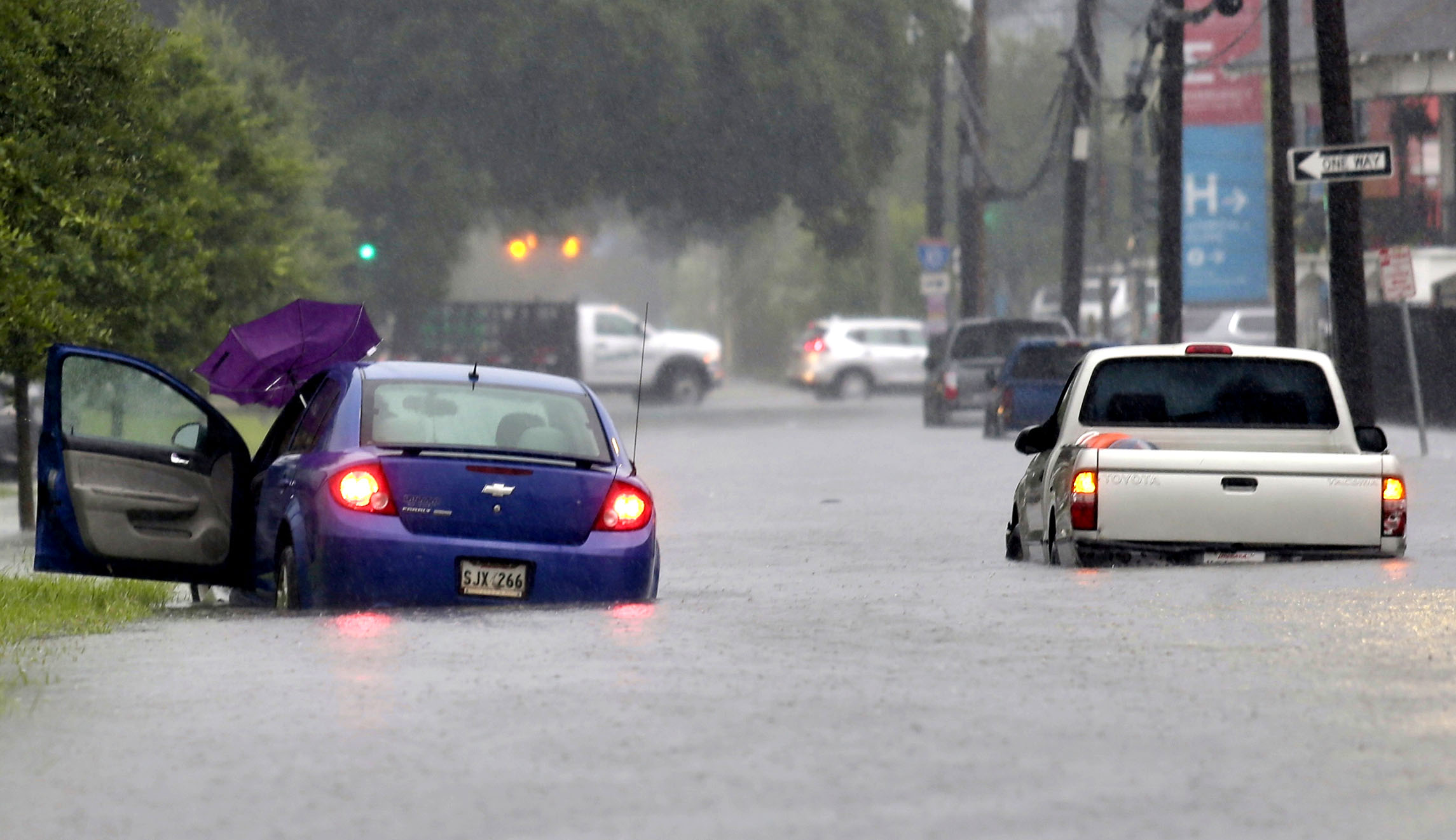
Coastal Louisiana is getting slammed by heavy rain and flooding as a tropical system develops over the Gulf of Mexico, leading to what could be a catastrophic few days for the Bayou State.
The low pressure system, soon to be named Barry, is forecast to become a tropical storm Thursday and a hurricane by Friday before likely swinging into southwest Louisiana, with a landfall expected somewhere between the mouth of the Mississippi River and eastern Texas. That could compound an already treacherous situation in places such as New Orleans, where severe storms have triggered a flash flood emergency due to at least 10 inches of rain in some parts and even a tornado warning.
Recommended Stories


In its latest forecast, the National Hurricane Center predicts 6 to 12 inches of rain accumulation near and inland of the central Gulf Coast through early next week and up to 18 inches in some isolated areas. A hurricane watch was issued for southern coast of Louisiana in the afternoon Wednesday.
A #Hurricane Watch has been issued from the mouth of the Mississippi
River westward to Cameron Louisiana for Potential Tropical Cyclone 2. For more details see https://t.co/tW4KeFW0gB or https://t.co/SiZo8ohZMN @NWS #PTC2 pic.twitter.com/SCjLtdSGfX— National Hurricane Center (@NHC_Atlantic) July 10, 2019
The effects of the storm will be felt from the upper coast of Texas all the way to the panhandle of Florida, and will stretch inland to states such as Arkansas. The low pressure system is expected to make landfall Saturday as a Category 1 or 2 storm on the Saffir-Simpson Hurricane Wind Scale.
As Louisiana residents are being advised to gather emergency supplies and hunker down, Gov. John Bel Edwards declared a state of emergency on Wednesday, unlocking resources to assist state and local efforts to manage the situation as the system will likely produce storm surge, hurricane-force winds, and more than a foot of rain across the state.
UPDATE: NOAA’s #GOES16 monitors #PTC2, strengthening in the #GulfofMexico this afternoon, July 10, 2019. #tropicalstorm and #stormsurge watches have been issued for a portion of the #Louisiana coast. Latest: @NHC_Atlantic pic.twitter.com/b9YezGluBl
— NOAA Satellites PA (@NOAASatellitePA) July 10, 2019
“This is going to be a Louisiana event with coastal flooding and widespread, heavy rainfall potentially impacting every part of the state,” the Democrat said in a statement. “No one should take this storm lightly. As we know all too well in Louisiana, low intensity does not necessarily mean low impact. Now is the time to check your emergency supplies and get a game plan for your family and pets. I urge the public to continue monitoring local media for weather developments and follow the directions of local officials. We expect multiple parishes to declare states of emergency, and we stand ready to assist our local partners with all available resources. My office is in constant communication with FEMA, and we will continue to provide updates as necessary.”
Videos posted to social media by local media and residents show flooding in the streets of New Orleans, storm pumps gushing water, and even what looked to be a waterspout.
A lot of New Orleans was underwater this morning (and a lot of it still is). Some people broke out kayaks, others were forced to abandon cars in another episode of flooding.
How things happened this morning: https://t.co/alFEYwA81z
See full thread of updates below this tweet ⤵️ pic.twitter.com/3bcZkKlLuh
— NOLA.com (@NOLAnews) July 10, 2019
Bourbon Street is flooded #NewOrleans https://t.co/enXI6uwyn4 pic.twitter.com/1YHQAcEfqA
— Greg Diamond (@gdimeweather) July 10, 2019
The Pontiff Playground storm pump at the foot of Magnolia Drive in Old Metairie @NOLAnews pic.twitter.com/jo8XgENsIQ
— Stephanie Stokes (@stokesps) July 10, 2019
WOW! A waterspout formed over a lake in New Orleans as strong storms caused widespread flooding in the area. #LAWX pic.twitter.com/Aw6aRngvoS
— wdsu (@wdsu) July 10, 2019
A major point of concern is the Mississippi River, which is likely to reach dangerous levels due to a double whammy of heavy rainfall and storm surge from the ocean. River levees will be put to the test. Local Fox meteorologist David Bernard said “the Mississippi River is now forecast to crest near 20 feet on Saturday. Average levee height for New Orleans is 20 feet.”
BREAKING The Mississippi River is now forecast to crest near 20 feet on Saturday. Average levee height for New Orleans is 20 feet. #Barry @FOX8NOLA @spann pic.twitter.com/reslVopmjq
— David Bernard (@DavidBernardTV) July 10, 2019
Also at risk are the constellation of oil and gas rigs in the Gulf of Mexico, many of which are shutting off production and are being evacuated. Energy prices are expected to rise as a result.
Future #Barry forecast cone touching quite a few active oil rigs in the Gulf of Mexico. About 77% (~1900) rigs are currently in the NHC 5-Day cone. Gas prices are about to soar. pic.twitter.com/8Jm30ZjCIA
— Shane Brown (@SDBrownWX) July 10, 2019
The Air Force Reserve Hurricane Hunters took off on Wednesday for an investigative flight, which will help forecasters get a better look at the inner workings of the storm.
Our AF Reserve Hurricane Hunters takeoff ? for an investigative flight into a tropical depression over the Gulf of Mexico.#ReserveCitizenAirmen #ReserveReady #403WG #WC130J #SuperHercules #HurricaneHunters #WeatherReady #NOAA #NHC pic.twitter.com/mVcix5MdxX
— 403rd Wing (@403rdWing) July 10, 2019
So far, it has been a rather quiet Atlantic hurricane season, which officially began on June 1. There has only been one named storm so far, Andrea, which formed into an organized tropical system in May south of Bermuda and quickly petered out.
The National Oceanic and Atmospheric Administration, which is the parent agency of National Hurricane Center, predicted in May that the Atlantic hurricane season would be near-normal in 2019. They also predicted there would likely be between nine and 15 named storms with winds of 39 mph or higher, four to eight that could become hurricanes with winds of 74 mph or higher, and two to four major hurricanes that are Category 3, 4, or 5 storms with winds of 111 mph or higher.
The outlook reflected two “competing climate factors” this year. “The ongoing El Nino is expected to persist and suppress the intensity of the hurricane season. Countering El Nino is the expected combination of warmer-than-average sea-surface temperatures in the tropical Atlantic Ocean and Caribbean Sea, and an enhanced west African monsoon, both of which favor increased hurricane activity,” the National Oceanic and Atmospheric Administration said.
In the Pacific Ocean, there has been a little more activity with three named storms, including Barbara, which had been a powerful Category 4 hurricane but dissipated and the remnants of which brought some soggy weather to Hawaii.