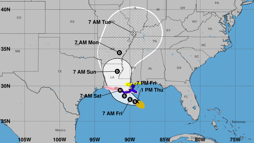
A low pressure system swooping across the Gulf of Mexico has become a tropical storm and is expected to reach hurricane strength before making landfall over Louisiana by the start of the weekend.
The biggest threat posed by Tropical Storm Barry is the flooding it could unleash upon southeast Louisiana, including New Orleans, the streets of which flooded due to heavy rain on Wednesday. Up to 20 inches of rain are expected in some areas over the weekend.
Recommended Stories


Barry is moving slowly westward across the norther Gulf of Mexico, according to the latest National Hurricane Center forecast. Dangerous storm surge, heavy rain, and strong wind conditions are expected across the entire area. Landfall could happen as early as Friday night, at which time Barry is expected to be a Category 1 hurricane on the Saffir-Simpson Hurricane Wind Scale.
The National Hurricane Center has issued storm surge and tropical storm watches across the coasts of Louisiana and Mississippi and a hurricane watch from the mouth of the Mississippi River to Cameron, Louisiana.

Gov. John Bel Edwards declared a state of emergency on Wednesday, unlocking resources to assist state and local efforts to manage the situation, and some residents in southeast Louisiana have been ordered to evacuate. The governor also activated 3,000 Louisiana National Guard personnel ready for the storm and said on Thursday he spoke with acting FEMA Administrator Peter Gaynor and requested a pre-landfall declaration of emergency from the federal government. “There three ways Louisiana floods: storm surge, high river, and rain. We’re going to have all three,” the Democrat said at a press conference Thursday.
Most recent rainfall forecast for Tropical Storm Barry from @NWSWPC covers a lot of real-estate with 5″, 10″ up to 20″.
In gallons:
6.3 Trillion over Louisiana
4.4 Trillion over Mississippi
3.3 Trillion over ArkansasThe Mississippi River has a lot of work to do. pic.twitter.com/sUcmlBtwMJ
— Ryan (@RyanMaue) July 11, 2019
The weather event will be a major test for levees protecting the Mississippi River, some of which have a height as low as 20 feet. Officials predict the water level could rise to around that height. “We’re confident the levees themselves are in good shape,” Ricky Boyett, a spokesman for the Army Corps of Engineers in New Orleans, told USA Today. “The big focus is height.”
Despite the risk of significant flooding, Edwards said, “Some good news is that we predict the Carrollton Gate to reach 19 feet rather than 20. This is a significant difference. We do NOT predict overtopping along the Mississippi River, with the possible exception of the Inner Harbor Navigation Canal.”
The @nwslmrfc has lowered the forecast for the Mississippi River at New Orleans to 19ft. The previous forecast was 20ft. Highest water levels are expected on Saturday. #lawx pic.twitter.com/lcVA2r7rRV
— NWS New Orleans (@NWSNewOrleans) July 11, 2019
Edwards noted this “the 258th consecutive day of the flood fight on the Mississippi River – the longest in history. And if Tropical Storm Barry becomes a hurricane, it would be the first time we’ve had the hurricane hit the state with rising rivers.”
Texas and Mississippi are also bracing for the storm, with emergency crews being activated and residents preparing for treacherous conditions.
There is a danger of life-threatening storm surge inundation along the coast of southern and southeastern Louisiana, where a Storm Surge Warning is now in effect https://t.co/TlYhzb6zDw #Barry @NHC_Surge pic.twitter.com/wpYiY66mcd
— National Hurricane Center (@NHC_Atlantic) July 11, 2019
Barry’s expected landfall comes nearly 14 years after Hurricane Katrina hit Louisiana as a Category 3 major hurricane, overwhelming levees around New Orleans and creating a flooding disaster in the Big Easy.
Also at risk this weekend are the constellation of oil and gas rigs in the Gulf of Mexico, many of which are shutting off production and have been evacuated. Energy prices have already begun to surge in some places as a result.
The National Hurricane Center began tracking the area of low pressure sweeping over southeastern states towards the warm waters of the Gulf earlier this week. Forecasters colloquially called this a “home brew” system, as it developed over the waters of the Gulf near the U.S. as opposed to off the west coast of Africa, which is not uncommon in the early part of the hurricane season.
NEW: NOAA’s #GOES16 shows a “sandwich loop” — a combination of visible and infrared imagery — of Potential Tropical Cyclone #Two, or #PTC2, this morning. @NHC_Atlantic predicts it will become a #TropicalDepression later today. pic.twitter.com/51W1MMpei4
— NOAA Satellites PA (@NOAASatellitePA) July 11, 2019
So far, it has been a rather quiet Atlantic hurricane season, which officially began on June 1. There has only been one named storm so far, Andrea, which formed into an organized tropical system in May south of Bermuda and quickly petered out.
The National Oceanic and Atmospheric Administration, which is the parent agency of National Hurricane Center, predicted in May that the Atlantic hurricane season would be near-normal in 2019. They also predicted there would likely be between nine and 15 named storms with winds of 39 mph or higher, four to eight that could become hurricanes with winds of 74 mph or higher, and two to four major hurricanes that are Category 3, 4, or 5 storms with winds of 111 mph or higher.
Tropical Storm Barry pic.twitter.com/GNh8qUhQdN
— Christina H Koch (@Astro_Christina) July 11, 2019
The outlook reflected two “competing climate factors” this year. “The ongoing El Nino is expected to persist and suppress the intensity of the hurricane season. Countering El Nino is the expected combination of warmer-than-average sea-surface temperatures in the tropical Atlantic Ocean and Caribbean Sea, and an enhanced west African monsoon, both of which favor increased hurricane activity,” the National Oceanic and Atmospheric Administration said.
In the Pacific Ocean, there has been a little more activity with three named storms, including Barbara, which had been a powerful Category 4 hurricane but dissipated and the remnants of which brought some soggy weather to Hawaii.